Franklin Falls via Denny Creek Road and Franklin Falls Trail
The Franklin Falls Trail is an enjoyable and scenic hike through the lush forests of the Mount Baker-Snoqualmie National Forest. As you make your way along the trail, you'll pass towering pines, moss-covered boulders, and the sounds of the South Fork Snoqualmie River, which provides a peaceful backdrop. The trail culminates in a stunning view of the 70-foot Franklin Falls, where the mist from the cascading water offers a refreshing experience, especially in warmer weather. Despite the trail's popularity, it remains accessible to hikers of all levels, with only a few slippery sections near the falls that require caution. #Hiking #Waterfall #Forest #Nature #River
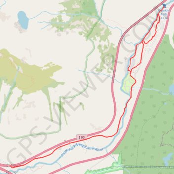
- Distance: 13.9 Km
- Elevation gain: 393 m
- Maximum elevation: 806 m
- Elevation loss: 389 m
- Minimum elevation: 577 m
Interactive trail map
Trail profile
- Distance: 13.9 Km
- Elevation gain: 393 m
- Maximum elevation: 806 m
- Elevation loss: 389 m
- Minimum elevation: 577 m
About this trail
Name: Franklin Falls via Denny Creek Road and Franklin Falls Trail trail, distance, elevation, map, profile, GPS track
Start: Denny Creek Road, Rockdale, King County, Washington, United States (47.39515 -121.47412)
End: Denny Creek Road, King County, Washington, United States (47.39543 -121.47504)
Coordinates: 47.39510 -121.47504 47.42492 -121.43285
Other hiking, mountain biking, running and outdoor activity trails
Click on a trail to view its statistics, map and profile.
Granite Mountain Trail in Mount Baker Snoqualmie National Forest
United States > Washington > King County
The Granite Mountain Trail, located near Snoqualmie Pass in Washington’s Mount Baker-Snoqualmie National Forest, offers an exhilarating hiking experience with remarkable views. As you ascend, you’ll pass through a lush forest before reaching exposed rocky meadows and the fire lookout that provide stunning…
Distance: 12.8 Km • Elevation gain: 1,146 m • Maximum elevation: 1,695 m
Melakwa Lake via Denny Creek Trail in Alpine Lakes Wilderness
United States > Washington > King County
The Melakwa Lake via Denny Creek Trail offers a captivating journey through the Alpine Lakes Wilderness. The route begins in lush forested areas, where hikers can enjoy views of cascading waterfalls, including the dramatic Keekwulee Falls, before ascending to rocky and open terrain. The trail culminates at…
Distance: 14.0 Km • Elevation gain: 865 m • Maximum elevation: 1,417 m
Franklin Falls Trail in Mount Baker-Snoqualmie National Forest
United States > Washington > King County
The Franklin Falls Trail in Mount Baker-Snoqualmie National Forest offers a delightful journey through lush forests alongside the South Fork of the Snoqualmie River. Hikers are treated to the soothing sounds of the river and the vibrant greenery of the forest, with occasional glimpses of the surrounding…
Distance: 3.6 Km • Elevation gain: 104 m • Maximum elevation: 788 m
Granite Mountain Trail in Alpine Lakes Wilderness
United States > Washington > King County
Distance: 13.6 Km • Elevation gain: 1,175 m • Maximum elevation: 1,694 m
Northern part of the Pacific Crest Trail (PCT)
United States > Oregon > Klamath County
Hike on the Pacific Crest National Scenic Trail from Crater Lake to Canada Border through Oregon and Washington along the Sierra Nevada and Cascade mountain ranges. #Hiking #Mountain #SierraNevada #Cascade #Nature #Forest #Park #PCT
Distance: 1,198.3 Km • Elevation gain: 44,308 m • Maximum elevation: 2,307 m