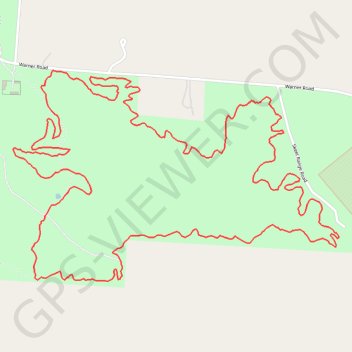
South Horton Inner Loop
- Distance: 6.5 Km
- Elevation gain: 48 m
- Maximum elevation: 226 m
- Elevation loss: 48 m
- Minimum elevation: 206 m
Interactive trail map
Trail profile
- Distance: 6.5 Km
- Elevation gain: 48 m
- Maximum elevation: 226 m
- Elevation loss: 48 m
- Minimum elevation: 206 m
About this trail
Name: South Horton Inner Loop trail, distance, elevation, map, profile, GPS track
Coordinates: 35.57640 -86.69004 35.58344 -86.67668
Other hiking, mountain biking, running and outdoor activity trails
Click on a trail to view its statistics, map and profile.
Gmaps Pedometer Route
United States > Kentucky > Fulton County > Hickman
Distance: 502.9 Km • Elevation gain: 4,204 m • Maximum elevation: 592 m