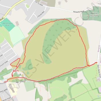
Aberbargoed old colliery paths
- Distance: 2.7 Km
- Elevation gain: 76 m
- Maximum elevation: 295 m
- Elevation loss: 86 m
- Minimum elevation: 221 m
- Moving time: 39 m 37 s
- Moving speed: 4.1 Km/h
- Maximum speed: 5.9 Km/h
- Total time: 39 m 37 s
- Global speed: 4.1 Km/h
Interactive trail map
Trail profile
- Distance: 2.7 Km
- Elevation gain: 76 m
- Maximum elevation: 295 m
- Elevation loss: 86 m
- Minimum elevation: 221 m
- Moving time: 39 m 37 s
- Moving speed: 4.1 Km/h
- Maximum speed: 5.9 Km/h
- Total time: 39 m 37 s
- Global speed: 4.1 Km/h
About this trail
Name: Aberbargoed old colliery paths trail, distance, elevation, map, profile, GPS track
Coordinates: 51.69021 -3.21997 51.69525 -3.20798
Other hiking, mountain biking, running and outdoor activity trails
Click on a trail to view its statistics, map and profile.
The Headstock 500
United Kingdom > Wales > Newport > Newport
Distance: 483.5 Km • Elevation gain: 9,616 m • Maximum elevation: 691 m