Coldwater Lake to Iron Creek Campground
Gravel
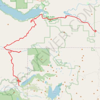
- Distance: 71.2 Km
- Elevation gain: 2,039 m
- Maximum elevation: 983 m
- Elevation loss: 2,465 m
- Minimum elevation: 222 m
Interactive trail map
Trail profile
- Distance: 71.2 Km
- Elevation gain: 2,039 m
- Maximum elevation: 983 m
- Elevation loss: 2,465 m
- Minimum elevation: 222 m
About this trail
Name: Coldwater Lake to Iron Creek Campground trail, distance, elevation, map, profile, GPS track
Start: Coldwater Lake Road, Cowlitz County, Washington, United States (46.28970 -122.27123)
End: Iron Creek Campground Loop, Lewis County, Washington, United States (46.42999 -121.98264)
Coordinates: 46.28967 -122.32972 46.47393 -121.98264
Other hiking, mountain biking, running and outdoor activity trails
Click on a trail to view its statistics, map and profile.
Northern part of the Pacific Crest Trail (PCT)
United States > Oregon > Klamath County
Hike on the Pacific Crest National Scenic Trail from Crater Lake to Canada Border through Oregon and Washington along the Sierra Nevada and Cascade mountain ranges. #Hiking #Mountain #SierraNevada #Cascade #Nature #Forest #Park #PCT
Distance: 1,198.3 Km • Elevation gain: 44,308 m • Maximum elevation: 2,307 m
Goat Mountain and Green River Secrets
United States > Washington > Skamania County
Green river trail western section
Distance: 43.4 Km • Elevation gain: 1,698 m • Maximum elevation: 1,530 m
Mt. Margaret to Green River Escape
United States > Washington > Cowlitz County
Distance: 72.5 Km • Elevation gain: 2,557 m • Maximum elevation: 1,740 m