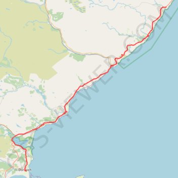
Dunbeath - Dornoch
- Distance: 72.9 Km
- Elevation gain: 898 m
- Maximum elevation: 230 m
- Elevation loss: 945 m
- Minimum elevation: 0 m
- Moving time: 4 h 40 m
- Moving speed: 15.6 Km/h
- Maximum speed: 53.4 Km/h
- Total time: 7 h 16 m
- Global speed: 10.0 Km/h
Interactive trail map
Trail profile
- Distance: 72.9 Km
- Elevation gain: 898 m
- Maximum elevation: 230 m
- Elevation loss: 945 m
- Minimum elevation: 0 m
- Moving time: 4 h 40 m
- Moving speed: 15.6 Km/h
- Maximum speed: 53.4 Km/h
- Total time: 7 h 16 m
- Global speed: 10.0 Km/h
About this trail
Name: Dunbeath - Dornoch trail, distance, elevation, map, profile, GPS track
Start: Mulbuie, Houstry, Highland, Scotland, KW6 6EL, United Kingdom (58.25036 -3.42134)
Coordinates: 57.87611 -4.08432 58.25038 -3.42056
Other hiking, mountain biking, running and outdoor activity trails
Click on a trail to view its statistics, map and profile.
John O'Groats Trail - Helmsdale to Berriedale
United Kingdom > Scotland > Highland > Helmsdale
Distance: 17.6 Km • Elevation gain: 811 m • Maximum elevation: 213 m
John O'Groats Trail - Berriedale to Dunbeath
United Kingdom > Scotland > Highland > Berriedale > Langwell House
Distance: 9.7 Km • Elevation gain: 428 m • Maximum elevation: 153 m
John O'Groats Trail - Brora to Helmsdale
United Kingdom > Scotland > Highland > Brora
Distance: 21.3 Km • Elevation gain: 249 m • Maximum elevation: 100 m