Backpacking Death Canyon
Backpacking, hiking
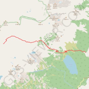
- Distance: 14.4 Km
- Elevation gain: 832 m
- Maximum elevation: 2,608 m
- Elevation loss: 286 m
- Minimum elevation: 2,047 m
- Moving time: 3 h 34 m
- Moving speed: 4.0 Km/h
- Maximum speed: 11.7 Km/h
- Total time: 5 h 25 m
- Global speed: 2.6 Km/h
Interactive trail map
Trail profile
- Distance: 14.4 Km
- Elevation gain: 832 m
- Maximum elevation: 2,608 m
- Elevation loss: 286 m
- Minimum elevation: 2,047 m
- Moving time: 3 h 34 m
- Moving speed: 4.0 Km/h
- Maximum speed: 11.7 Km/h
- Total time: 5 h 25 m
- Global speed: 2.6 Km/h
About this trail
Name: Backpacking Death Canyon trail, distance, elevation, map, profile, GPS track
Start: Teton County, Wyoming, United States (43.65511 -110.77673)
End: Death Canyon Trail, Teton County, Wyoming, United States (43.66379 -110.88524)
Coordinates: 43.65478 -110.88530 43.67101 -110.77668