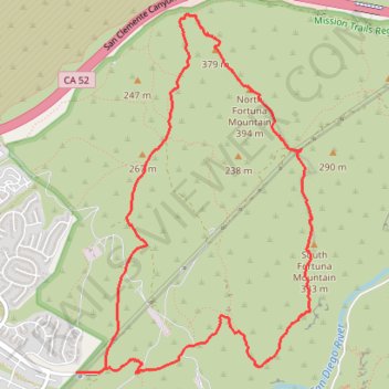
Fortuna Mountain Loop
Interactive trail map
Trail profile
- Distance: 10.3 Km
- Elevation gain: 416 m
- Maximum elevation: 386 m
- Elevation loss: 416 m
- Minimum elevation: 111 m
- Moving time: 3 h 21 m
- Moving speed: 3.1 Km/h
- Maximum speed: 7.5 Km/h
- Total time: 4 h 12 m
- Global speed: 2.4 Km/h
About this trail
Name: Fortuna Mountain Loop trail, distance, elevation, map, profile, GPS track
Coordinates: 32.82528 -117.07657 32.85262 -117.05517
Other hiking, mountain biking, running and outdoor activity trails
Click on a trail to view its statistics, map and profile.
Fortuna Mountain Loop Trail in Mission Trails Regional Park
United States > California > San Diego County > San Diego
The Fortuna Mountain Loop Trail in Mission Trails Regional Park offers hikers expansive vistas of rolling hills and the vibrant San Diego cityscape. Along the route, the challenging ascent up South Fortuna's wooden steps, often dubbed the "Stairway to Heaven," provides both a physical test and rewarding…
Distance: 10.1 Km • Elevation gain: 418 m • Maximum elevation: 386 m