Brick Hill
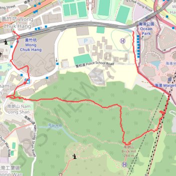
Interactive trail map
Trail profile
- Distance: 3.0 Km
- Elevation gain: 251 m
- Maximum elevation: 259 m
- Elevation loss: 265 m
- Minimum elevation: 7 m
- Moving time: 48 m 28 s
- Moving speed: 3.7 Km/h
- Maximum speed: 18.0 Km/h
- Total time: 1 h 44 m
- Global speed: 1.7 Km/h
About this trail
Name: Brick Hill trail, distance, elevation, map, profile, GPS track
Coordinates: 22.24170 114.16608 22.24800 114.17582
Other hiking, mountain biking, running and outdoor activity trails
Click on a trail to view its statistics, map and profile.
Wilson Trail Full Route
China > Hong Kong > Hong Kong Island
Distance: 81.2 Km • Elevation gain: 4,430 m • Maximum elevation: 613 m
Hong Kong island ride
China > Hong Kong > Hong Kong Island
#Bike
Distance: 61.8 Km • Elevation gain: 2,152 m • Maximum elevation: 505 m