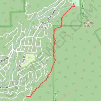
Ernie Maxwell Scenic Trail
Starting from the Idyllwild side near Tahquitz View Drive, the Ernie Maxwell Scenic Trail climbs gently through shaded pine, oak, cedar and manzanita forest on the lower slopes of the San Jacinto Mountains.
The route passes granite boulders and seasonal drainages before opening occasional views across Strawberry Valley toward Suicide Rock and Lily Rock.
It finishes at Humber Park, a forested mountain trailhead beneath the higher ridges of the San Jacinto Wilderness and the approaches to Devils Slide Trail.
#Hiking #Nature #Forest #Mountain #Wilderness #Views
- Distance: 3.8 Km
- Elevation gain: 285 m
- Maximum elevation: 1,966 m
- Elevation loss: 83 m
- Minimum elevation: 1,756 m
- Moving time: 22 m 23 s
- Moving speed: 10.1 Km/h
- Maximum speed: 11.6 Km/h
- Total time: 22 m 23 s
- Global speed: 10.1 Km/h
Interactive trail map
Trail profile
- Distance: 3.8 Km
- Elevation gain: 285 m
- Maximum elevation: 1,966 m
- Elevation loss: 83 m
- Minimum elevation: 1,756 m
- Moving time: 22 m 23 s
- Moving speed: 10.1 Km/h
- Maximum speed: 11.6 Km/h
- Total time: 22 m 23 s
- Global speed: 10.1 Km/h
About this trail
Name: Ernie Maxwell Scenic Trail trail, distance, elevation, map, profile, GPS track
End: Humber Park Trailhead, Riverside County, California, 92599, United States (33.76468 -116.68717)
Coordinates: 33.74036 -116.70229 33.76468 -116.68696
Other hiking, mountain biking, running and outdoor activity trails
Click on a trail to view its statistics, map and profile.
Tahquitz Peak via South Ridge Trail in San Jacinto Wilderness
United States > California > Riverside County
The South Ridge Trail to Tahquitz Peak offers hikers an invigorating ascent through a dense pine and oak forest, with expansive views of Idyllwild, Suicide Rock, and Lily Rock emerging as you climb. As you gain elevation, the trail opens up to breathtaking vistas of the San Jacinto Mountains, offering glimpses…
Distance: 10.6 Km • Elevation gain: 698 m • Maximum elevation: 2,667 m
Pacific Crest Trail (PCT) through San Bernardino Forest and Santa Rosa and San Jacinto Mountains
United States > California > Riverside County
Hike from Bull Canyon Parking to Snow Creek along the Pacific Crest National Scenic Trail via Lion Peak, Pyramid Peak, Cedar Spring, Palm View Peak, Fobes Saddle, Spitler Peak, Apache Peak, Apache Spring, Antsell Rock, South Peak, Red Tahquitz, Tahquitz Meadow, Powderbox Spring, Middle Spring, Jolley Spring,…
Distance: 95.0 Km • Elevation gain: 3,982 m • Maximum elevation: 2,737 m
Suicide Rock
United States > California > Riverside County > Idyllwild
Hike to Suicide Rock by the Deer Springs Trail and the Suicide Rock Trail in the San Bernardino National Forest and the Mount San Jacinto State Wilderness. #Hiking #Mountain #Nature #Forest #Wilderness
Distance: 5.4 Km • Elevation gain: 568 m • Maximum elevation: 2,265 m
Mount Jacinto Loop
United States > California > Riverside County > Idyllwild
Loop Hike to Mount Jacinto via Deer Springs Trail, Pacific Crest Trail (PCT), Peak Trail and Wellman's Cienaga Trail in the San Bernardino National Forest and the Mount San Jacinto State Park. #Hiking #Loop #Mountain #Nature #Forest #Park #PCT
Distance: 28.0 Km • Elevation gain: 1,646 m • Maximum elevation: 3,279 m
Suicide Rock
United States > California > Riverside County > Idyllwild
Hike from Idyllwild Nature Center to Suicide Rock via Deer Springs Trail and Suicide Rock Trail in the San Bernardino National Forest and the Mount San Jacinto State Wilderness. #Hiking #Mountain #Nature #Forest #Wilderness
Distance: 12.0 Km • Elevation gain: 638 m • Maximum elevation: 2,262 m
Ernie Maxwell Trail
United States > California > Riverside County > Idyllwild
Riverside County Hiking
Distance: 7.9 Km • Elevation gain: 354 m • Maximum elevation: 1,965 m