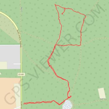
Big Hammock
Loop hike to Big Hammock via Mansfield Pond in the Withlacoochee State Forest and the Citrus Wildlife Management Area. #Hiking #Loop #Nature #Forest #Lake
- Distance: 5.1 Km
- Elevation gain: 42 m
- Maximum elevation: 28 m
- Elevation loss: 42 m
- Minimum elevation: 4 m
- Moving time: 1 h 34 m
- Moving speed: 3.2 Km/h
- Maximum speed: 6.9 Km/h
- Total time: 2 h 10 m
- Global speed: 2.3 Km/h
Interactive trail map
Trail profile
- Distance: 5.1 Km
- Elevation gain: 42 m
- Maximum elevation: 28 m
- Elevation loss: 42 m
- Minimum elevation: 4 m
- Moving time: 1 h 34 m
- Moving speed: 3.2 Km/h
- Maximum speed: 6.9 Km/h
- Total time: 2 h 10 m
- Global speed: 2.3 Km/h
About this trail
Name: Big Hammock trail, distance, elevation, map, profile, GPS track
Coordinates: 28.78350 -82.45034 28.79500 -82.44222