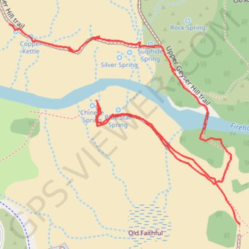
Old Faithful - Geyser Hill
Blue Star Springs - Chinese Spring - Sulphide Spring - Bronze Spring - Silver Spring - Beehive Geyser - Scissors Spring - Copper Kettle
Yellowstone National Park
- Distance: 1.1 Km
- Elevation gain: 9 m
- Maximum elevation: 2,248 m
- Elevation loss: 14 m
- Minimum elevation: 2,241 m
- Moving time: 18 m
- Moving speed: 3.6 Km/h
- Maximum speed: 7.1 Km/h
- Total time: 23 m 56 s
- Global speed: 2.7 Km/h
Interactive trail map
Trail profile
- Distance: 1.1 Km
- Elevation gain: 9 m
- Maximum elevation: 2,248 m
- Elevation loss: 14 m
- Minimum elevation: 2,241 m
- Moving time: 18 m
- Moving speed: 3.6 Km/h
- Maximum speed: 7.1 Km/h
- Total time: 23 m 56 s
- Global speed: 2.7 Km/h
About this trail
Name: Old Faithful - Geyser Hill trail, distance, elevation, map, profile, GPS track
Start: Upper Geyser Basin Trail, Teton County, Wyoming, 82180, United States (44.46055 -110.82657)
Coordinates: 44.46055 -110.83048 44.46298 -110.82657