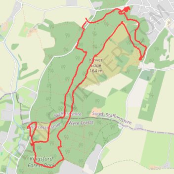
Kinver Edge Loop Walk
- Distance: 9.1 Km
- Elevation gain: 253 m
- Maximum elevation: 161 m
- Elevation loss: 248 m
- Minimum elevation: 66 m
- Moving time: 3 h 2 m
- Moving speed: 3.0 Km/h
- Maximum speed: 14.7 Km/h
- Total time: 4 h 51 m
- Global speed: 1.9 Km/h
Interactive trail map
Trail profile
- Distance: 9.1 Km
- Elevation gain: 253 m
- Maximum elevation: 161 m
- Elevation loss: 248 m
- Minimum elevation: 66 m
- Moving time: 3 h 2 m
- Moving speed: 3.0 Km/h
- Maximum speed: 14.7 Km/h
- Total time: 4 h 51 m
- Global speed: 1.9 Km/h
About this trail
Name: Kinver Edge Loop Walk trail, distance, elevation, map, profile, GPS track
Coordinates: 52.43195 -2.26053 52.45048 -2.23812