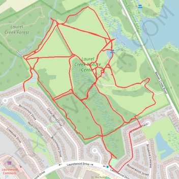
Laurel Creek Nature Centre
- Distance: 8.2 Km
- Elevation gain: 43 m
- Maximum elevation: 354 m
- Elevation loss: 43 m
- Minimum elevation: 344 m
- Moving time: 57 m 30 s
- Moving speed: 8.6 Km/h
- Maximum speed: 12.9 Km/h
- Total time: 58 m 46 s
- Global speed: 8.4 Km/h
Interactive trail map
Trail profile
- Distance: 8.2 Km
- Elevation gain: 43 m
- Maximum elevation: 354 m
- Elevation loss: 43 m
- Minimum elevation: 344 m
- Moving time: 57 m 30 s
- Moving speed: 8.6 Km/h
- Maximum speed: 12.9 Km/h
- Total time: 58 m 46 s
- Global speed: 8.4 Km/h
About this trail
Name: Laurel Creek Nature Centre trail, distance, elevation, map, profile, GPS track
Coordinates: 43.47243 -80.59229 43.48090 -80.58295