Star Creek / Comlaroi Road explore
- Distance: 5.0 Km
- Elevation gain: 227 m
- Maximum elevation: 308 m
- Elevation loss: 227 m
- Minimum elevation: 100 m
- Moving time: 41 m 6 s
- Moving speed: 7.3 Km/h
- Maximum speed: 25.2 Km/h
- Total time: 41 m 6 s
- Global speed: 7.3 Km/h
Interactive trail map
Trail profile
- Distance: 5.0 Km
- Elevation gain: 227 m
- Maximum elevation: 308 m
- Elevation loss: 227 m
- Minimum elevation: 100 m
- Moving time: 41 m 6 s
- Moving speed: 7.3 Km/h
- Maximum speed: 25.2 Km/h
- Total time: 41 m 6 s
- Global speed: 7.3 Km/h
About this trail
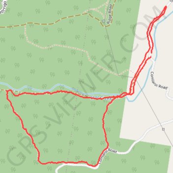
Name: Star Creek / Comlaroi Road explore trail, distance, elevation, map, profile, GPS track
Coordinates: -30.23522 152.99135 -30.22267 153.00585
Other hiking, mountain biking, running and outdoor activity trails
Click on a trail to view its statistics, map and profile.
Orara West State Forest
Australia > New South Wales > Coramba
Morning Run
Distance: 8.8 Km • Elevation gain: 506 m • Maximum elevation: 368 m