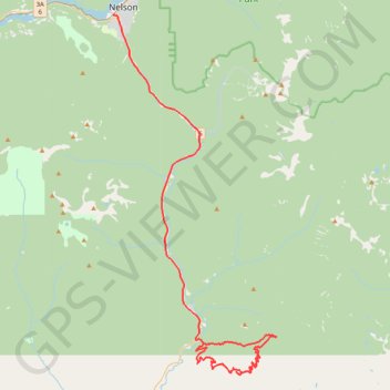
Porcupine
- Distance: 60.6 Km
- Elevation gain: 1,948 m
- Maximum elevation: 1,762 m
- Elevation loss: 1,772 m
- Minimum elevation: 540 m
Interactive trail map
Trail profile
- Distance: 60.6 Km
- Elevation gain: 1,948 m
- Maximum elevation: 1,762 m
- Elevation loss: 1,772 m
- Minimum elevation: 540 m
About this trail
Name: Porcupine trail, distance, elevation, map, profile, GPS track
Coordinates: 49.23581 -117.30022 49.48966 -117.12412
Other hiking, mountain biking, running and outdoor activity trails
Click on a trail to view its statistics, map and profile.
Huckleberry Pass
Canada > British Columbia > Regional District of Central Kootenay > Area G (Salmo Valley) > Ymir
Distance: 23.9 Km • Elevation gain: 900 m • Maximum elevation: 1,481 m
Castlegar - Crawford Bay
Canada > British Columbia > Regional District of Central Kootenay > Area J (Lower Arrow/Columbia) > Raspberry
Kootenay River. #Bike
Distance: 91.0 Km • Elevation gain: 1,194 m • Maximum elevation: 694 m