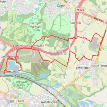
Run from Skelton Lake to Hollinthorpe and back via the north of Swillington
Uncharted territory
- Distance: 15.5 Km
- Elevation gain: 151 m
- Maximum elevation: 90 m
- Elevation loss: 150 m
- Minimum elevation: 14 m
Interactive trail map
Trail profile
- Distance: 15.5 Km
- Elevation gain: 151 m
- Maximum elevation: 90 m
- Elevation loss: 150 m
- Minimum elevation: 14 m
About this trail
Name: Run from Skelton Lake to Hollinthorpe and back via the north of Swillington trail, distance, elevation, map, profile, GPS track
Coordinates: 53.76590 -1.47761 53.78250 -1.40938
Other hiking, mountain biking, running and outdoor activity trails
Click on a trail to view its statistics, map and profile.
Gravel ride loop from Sheffield to Hornsea and York
United Kingdom > England > Sheffield
Distance: 333.3 Km • Elevation gain: 1,836 m • Maximum elevation: 222 m