BELLEVUE
Bike Loop Bellevue
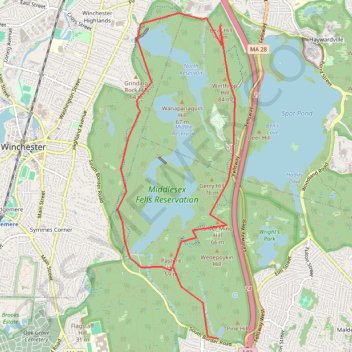
- Distance: 11.2 Km
- Elevation gain: 126 m
- Maximum elevation: 88 m
- Elevation loss: 126 m
- Minimum elevation: 29 m
Interactive trail map
Trail profile
- Distance: 11.2 Km
- Elevation gain: 126 m
- Maximum elevation: 88 m
- Elevation loss: 126 m
- Minimum elevation: 29 m
About this trail
Name: BELLEVUE trail, distance, elevation, map, profile, GPS track
Coordinates: 42.43095 -71.12285 42.46711 -71.10512
Other hiking, mountain biking, running and outdoor activity trails
Click on a trail to view its statistics, map and profile.
Skyline and Reservoir Loop Trail in Middlesex Fells Reservation
United States > Massachusetts > Middlesex County > Medford
The Skyline and Reservoir Loop Trail offers a moderately challenging experience with rugged terrain, rewarding hikers with sweeping views of the Boston skyline. As the trail winds through forested sections and around scenic reservoirs, it also climbs to rocky summits, providing natural vantage points. This…
Distance: 12.9 Km • Elevation gain: 167 m • Maximum elevation: 79 m
The Trails of Groton with 3k Dirt in Lincoln/Lexington (Arlington Start)
United States > Massachusetts > Middlesex County > Arlington
Distance: 111.4 Km • Elevation gain: 1,034 m • Maximum elevation: 109 m
2024 Bikes Not Bombs Bike-a-thon (BAT) Agony & Ecstasy
United States > Massachusetts > Suffolk County > Boston
Distance: 171.3 Km • Elevation gain: 1,714 m • Maximum elevation: 183 m
Nahant and Northern Strand Trail
United States > Massachusetts > Suffolk County > Boston
Distance: 70.3 Km • Elevation gain: 388 m • Maximum elevation: 23 m