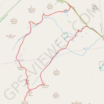
Dix Mountain Loop
Loop hike on the Dix Range via Boquet Forks Trail, Shoebox Falls, Lillypad Pond, Grace Peak, Grace Peak Trail, South Dix Lookout, South Dix, Dix Range Trail, Macomb Mountain, Hough Peak, Beckhorn Trail, Dix Mountain, Dix Trail and Round Pond in the High Peaks Wilderness and the Adirondack Park. #Hiking #Loop #Mountain #Lake #River #Forest #Nature #Wilderness #Park
- Distance: 27.1 Km
- Elevation gain: 1,577 m
- Maximum elevation: 1,456 m
- Elevation loss: 1,493 m
- Minimum elevation: 403 m
- Moving time: 9 h 54 m
- Moving speed: 2.7 Km/h
- Maximum speed: 5.4 Km/h
- Total time: 11 h 23 m
- Global speed: 2.4 Km/h
Interactive trail map
Trail profile
- Distance: 27.1 Km
- Elevation gain: 1,577 m
- Maximum elevation: 1,456 m
- Elevation loss: 1,493 m
- Minimum elevation: 403 m
- Moving time: 9 h 54 m
- Moving speed: 2.7 Km/h
- Maximum speed: 5.4 Km/h
- Total time: 11 h 23 m
- Global speed: 2.4 Km/h
About this trail
Name: Dix Mountain Loop trail, distance, elevation, map, profile, GPS track
Start: State Highway 73, Town of Keene, Essex County, New York, United States (44.11223 -73.70777)
End: Dix Trail, Town of Keene, Essex County, New York, United States (44.13129 -73.73079)
Coordinates: 44.05169 -73.79057 44.13129 -73.70772
Other hiking, mountain biking, running and outdoor activity trails
Click on a trail to view its statistics, map and profile.