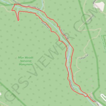
Muir Woods Redwook Creek Loop
Interactive trail map
Trail profile
- Distance: 3.1 Km
- Elevation gain: 82 m
- Maximum elevation: 117 m
- Elevation loss: 82 m
- Minimum elevation: 58 m
About this trail
Name: Muir Woods Redwook Creek Loop trail, distance, elevation, map, profile, GPS track
Start: Fern Creek Trail, Marin County, California, 94841, United States (37.89274 -122.57252)
End: Fern Creek Trail, Marin County, California, 94841, United States (37.89276 -122.57254)
Coordinates: 37.89274 -122.58179 37.90140 -122.57252
Other hiking, mountain biking, running and outdoor activity trails
Click on a trail to view its statistics, map and profile.
Canopy, Lost and Fern Creek Trails Loop in Muir Woods National Monument
United States > California > Marin County
The Canopy, Lost, and Fern Creek Trails Loop in Muir Woods National Monument offers hikers a serene journey through towering redwoods, lush fern-lined paths, and tranquil creek crossings. The trail ascends gently, providing elevated views of the forest canopy, and descends alongside the picturesque Fern Creek,…
Distance: 4.9 Km • Elevation gain: 262 m • Maximum elevation: 224 m
Muir Woods Bootjack Trail Loop
United States > California > Marin County
Loop hike via Fern Creek Trail, Bootjack Trail, TCC Trail, Stapleveldt Trail, Ben Johnson Trail and Hillside Trail in the Muir Woods National Monument and Mount Tamalpais State Park. #Hiking #Loop #Forest #River #Nature #Mountain #Park
Distance: 9.5 Km • Elevation gain: 506 m • Maximum elevation: 410 m
Muir Woods Canopy Trail Loop
United States > California > Marin County
Loop hike through Muir Woods National Monument via Canopy Trail and Fern Creek Trail along the Fern Creek and the Redwook Creek via the Redwood Tree Slice, the Pinchot Tree and the Cathedral Grove. #Hiking #Loop #Forest #Nature #Mountain #River
Distance: 4.7 Km • Elevation gain: 247 m • Maximum elevation: 220 m
Point Reyes Loop
United States > California > Marin County > Mill Valley
Distance: 100.3 Km • Elevation gain: 1,900 m • Maximum elevation: 236 m