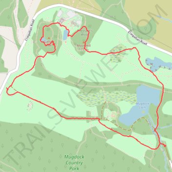
Loop walk in Mugdock County Park
- Distance: 4.6 Km
- Elevation gain: 44 m
- Maximum elevation: 179 m
- Elevation loss: 44 m
- Minimum elevation: 151 m
- Moving time: 1 h 19 m
- Moving speed: 3.5 Km/h
- Maximum speed: 9.0 Km/h
- Total time: 1 h 34 m
- Global speed: 2.9 Km/h
Interactive trail map
Trail profile
- Distance: 4.6 Km
- Elevation gain: 44 m
- Maximum elevation: 179 m
- Elevation loss: 44 m
- Minimum elevation: 151 m
- Moving time: 1 h 19 m
- Moving speed: 3.5 Km/h
- Maximum speed: 9.0 Km/h
- Total time: 1 h 34 m
- Global speed: 2.9 Km/h
About this trail
Name: Loop walk in Mugdock County Park trail, distance, elevation, map, profile, GPS track
End: Mugdock Road, Mugdock, Stirling, Scotland, G62 8BG, United Kingdom (55.96344 -4.31765)
Coordinates: 55.96301 -4.33791 55.97228 -4.31707
Other hiking, mountain biking, running and outdoor activity trails
Click on a trail to view its statistics, map and profile.
Mugdock Country Park Walk
United Kingdom > Scotland > Stirling > Blanefield > Craigallian
Distance: 3.3 Km • Elevation gain: 36 m • Maximum elevation: 178 m
Pheasants's Wood Loop in Mugdock Country Park
United Kingdom > Scotland > Stirling > Blanefield > Craigallian
Distance: 1.2 Km • Elevation gain: 15 m • Maximum elevation: 178 m
Loop Walk at Mugdock Country Park
United Kingdom > Scotland > Stirling > Mugdock
Distance: 2.7 Km • Elevation gain: 35 m • Maximum elevation: 172 m
West Highland Way between Milngavie and Craigallian Loch
United Kingdom > Scotland > East Dunbartonshire > Milngavie
Distance: 7.4 Km • Elevation gain: 83 m • Maximum elevation: 117 m
Trails in and around Mugdock Country Park
United Kingdom > Scotland > Stirling > Mugdock
Distance: 3.7 Km • Elevation gain: 85 m • Maximum elevation: 163 m
West Highland Way: Milngavie to Mugdock Park
United Kingdom > Scotland > East Dunbartonshire > Glasgow
Distance: 6.8 Km • Elevation gain: 72 m • Maximum elevation: 115 m
Loop Trail in and around Mugdock Country Park
United Kingdom > Scotland > East Dunbartonshire > Milngavie
Distance: 3.9 Km • Elevation gain: 91 m • Maximum elevation: 163 m