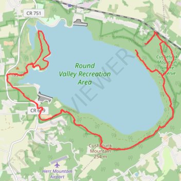
Round Valley Reservoir
- Distance: 32.8 Km
- Elevation gain: 1,004 m
- Maximum elevation: 256 m
- Elevation loss: 1,003 m
- Minimum elevation: 70 m
- Moving time: 2 h 45 m
- Moving speed: 11.9 Km/h
- Maximum speed: 35.6 Km/h
- Total time: 3 h 13 m
- Global speed: 10.2 Km/h
Interactive trail map
Trail profile
- Distance: 32.8 Km
- Elevation gain: 1,004 m
- Maximum elevation: 256 m
- Elevation loss: 1,003 m
- Minimum elevation: 70 m
- Moving time: 2 h 45 m
- Moving speed: 11.9 Km/h
- Maximum speed: 35.6 Km/h
- Total time: 3 h 13 m
- Global speed: 10.2 Km/h
About this trail
Name: Round Valley Reservoir trail, distance, elevation, map, profile, GPS track
Coordinates: 40.59597 -74.85949 40.62955 -74.79714
Other hiking, mountain biking, running and outdoor activity trails
Click on a trail to view its statistics, map and profile.
Creek Side Trail White Blaze Loop
United States > New Jersey > Hunterdon County > Readington Township > Cushetunk
Cushetunk Exploration
Distance: 9.7 Km • Elevation gain: 139 m • Maximum elevation: 113 m