Mineral Ridge Loop Trail in Idaho
The Mineral Ridge Loop Trail offers a peaceful and scenic hike through a classic forest of the Inland Northwest. As you climb, you’re rewarded with panoramic views of Lake Coeur d'Alene, particularly over Beauty and Wolf Lodge Bays. The trail is well-maintained, with interpretive signs along the way, making it a blend of nature, history, and stunning vistas. #Hiking #Loop #Lake #Forest #Nature
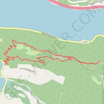
- Distance: 5.3 Km
- Elevation gain: 308 m
- Maximum elevation: 898 m
- Elevation loss: 303 m
- Minimum elevation: 658 m
- Moving time: 1 h 18 m
- Moving speed: 4.1 Km/h
- Maximum speed: 6.6 Km/h
- Total time: 1 h 27 m
- Global speed: 3.6 Km/h
Interactive trail map
Trail profile
- Distance: 5.3 Km
- Elevation gain: 308 m
- Maximum elevation: 898 m
- Elevation loss: 303 m
- Minimum elevation: 658 m
- Moving time: 1 h 18 m
- Moving speed: 4.1 Km/h
- Maximum speed: 6.6 Km/h
- Total time: 1 h 27 m
- Global speed: 3.6 Km/h
About this trail
Name: Mineral Ridge Loop Trail in Idaho trail, distance, elevation, map, profile, GPS track
End: Mineral Ridge Trail, Kootenai County, Idaho, 83877, United States (47.61518 -116.67790)
Coordinates: 47.61518 -116.67890 47.61884 -116.65752