Grotto Falls via Trillium Gap Trail in Great Smoky Mountains National Park
The hike to Grotto Falls offers a refreshing woodland experience within Great Smoky Mountains National Park. The trail takes you through a lush forest, featuring streams and wildflowers, leading to the 25-foot high Grotto Falls, where you can walk behind the waterfall—a rare and exciting feature of the hike. Though the path ascends steadily, it’s a manageable and rewarding trek for most, providing cool relief at the falls and picturesque scenery along the way. #Hiking #Waterfall #Forest #Nature
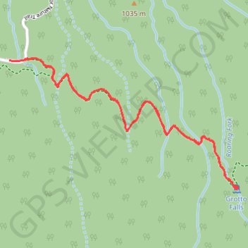
- Distance: 4.4 Km
- Elevation gain: 282 m
- Maximum elevation: 1,164 m
- Elevation loss: 284 m
- Minimum elevation: 981 m
- Moving time: 1 h 12 m
- Moving speed: 3.6 Km/h
- Maximum speed: 8.9 Km/h
- Total time: 1 h 30 m
- Global speed: 2.9 Km/h
Interactive trail map
Trail profile
- Distance: 4.4 Km
- Elevation gain: 282 m
- Maximum elevation: 1,164 m
- Elevation loss: 284 m
- Minimum elevation: 981 m
- Moving time: 1 h 12 m
- Moving speed: 3.6 Km/h
- Maximum speed: 8.9 Km/h
- Total time: 1 h 30 m
- Global speed: 2.9 Km/h
About this trail
Name: Grotto Falls via Trillium Gap Trail in Great Smoky Mountains National Park trail, distance, elevation, map, profile, GPS track
Coordinates: 35.67384 -83.46351 35.68038 -83.44944
Other hiking, mountain biking, running and outdoor activity trails
Click on a trail to view its statistics, map and profile.
Grotto Falls via Trillium Gap Trail in Great Smoky Mountains National Park
United States > Tennessee > Sevier County
Hiking the Trillium Gap Trail to Grotto Falls offers an immersive journey through old-growth hemlock forests, where vibrant wildflowers adorn the path. The trail's highlight is Grotto Falls, a 25-foot waterfall behind which hikers can walk, providing a unique perspective of the cascading water. #Hiking…
Distance: 4.1 Km • Elevation gain: 279 m • Maximum elevation: 1,163 m
Great Smoky Mountains Appalachian Trail
United States > North Carolina > Clay County
Hike through Great Smoky Mountains along Appalachian Trail via Standing Indian, Ridgepole Mountain, Yellow Bald, Wine Spring Bald, Copper Ridge Bald, Cheoah Bald, Wauchecha Bald, Fontana Dam, Thunderhead Mountain, Clingmans Dome, Mount Kephart and Mount Guyot. #Hiking #Mountain #Nature #Forest #Lake…
Distance: 231.7 Km • Elevation gain: 8,873 m • Maximum elevation: 2,013 m