Columbine Loop Trail in Cedar Niles Park
The Columbine Loop Trail offers hikers a pleasant escape through a diverse landscape featuring both cedar forests and open prairie areas. As you traverse the loop, you'll encounter rolling terrain, abundant wildflowers—especially the native columbine—and ample opportunities for wildlife observation. Well-marked and well-maintained, the trail is suitable for both hiking and mountain biking, making it an inviting destination for outdoor enthusiasts looking to enjoy nature in a serene setting. #Hiking #Loop #Forest #Nature
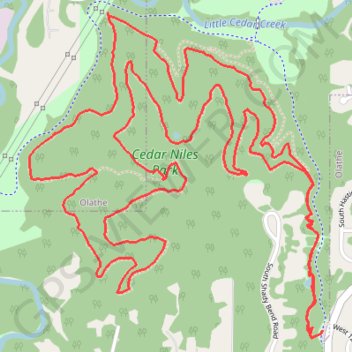
- Distance: 10.0 Km
- Elevation gain: 141 m
- Maximum elevation: 311 m
- Elevation loss: 141 m
- Minimum elevation: 277 m
- Moving time: 2 h 10 m
- Moving speed: 4.6 Km/h
- Maximum speed: 7.2 Km/h
- Total time: 2 h 16 m
- Global speed: 4.4 Km/h
Interactive trail map
Trail profile
- Distance: 10.0 Km
- Elevation gain: 141 m
- Maximum elevation: 311 m
- Elevation loss: 141 m
- Minimum elevation: 277 m
- Moving time: 2 h 10 m
- Moving speed: 4.6 Km/h
- Maximum speed: 7.2 Km/h
- Total time: 2 h 16 m
- Global speed: 4.4 Km/h
About this trail
Name: Columbine Loop Trail in Cedar Niles Park trail, distance, elevation, map, profile, GPS track
Start: Cedar Niles Park Trail, Olathe, Johnson County, Kansas, 66051, United States (38.89982 -94.87189)
End: Cedar Niles Park Trail, Olathe, Johnson County, Kansas, 66051, United States (38.89980 -94.87191)
Coordinates: 38.89952 -94.88618 38.91183 -94.87189