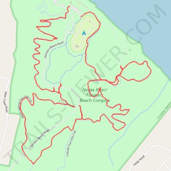
Flanners Beach and Croatan National Forest Loop
- Distance: 6.6 Km
- Elevation gain: 22 m
- Maximum elevation: 16 m
- Elevation loss: 22 m
- Minimum elevation: 6 m
- Moving time: 1 h 38 m
- Moving speed: 4.0 Km/h
- Maximum speed: 13.4 Km/h
- Total time: 1 h 45 m
- Global speed: 3.8 Km/h
Interactive trail map
Trail profile
- Distance: 6.6 Km
- Elevation gain: 22 m
- Maximum elevation: 16 m
- Elevation loss: 22 m
- Minimum elevation: 6 m
- Moving time: 1 h 38 m
- Moving speed: 4.0 Km/h
- Maximum speed: 13.4 Km/h
- Total time: 1 h 45 m
- Global speed: 3.8 Km/h
About this trail
Name: Flanners Beach and Croatan National Forest Loop trail, distance, elevation, map, profile, GPS track
Start: Flanners Beach Road, Craven County, North Carolina, United States (34.98342 -76.94927)
Coordinates: 34.97403 -76.95285 34.98342 -76.94340
Other hiking, mountain biking, running and outdoor activity trails
Click on a trail to view its statistics, map and profile.
Neuse River/Flanners Beach Complex Loop
United States > North Carolina > Craven County
Distance: 6.4 Km • Elevation gain: 27 m • Maximum elevation: 15 m
Neuse River Beach Swamp Trail and Flanners Beach Campground Loop in Croatan National Forest
United States > North Carolina > Craven County
Distance: 3.5 Km • Elevation gain: 21 m • Maximum elevation: 14 m
Morning hike at Flanners Beach and Croatan National Forest Loop
United States > North Carolina > Craven County
Distance: 3.1 Km • Elevation gain: 24 m • Maximum elevation: 16 m
Flanners Beach and Croatan National Forest Loop
United States > North Carolina > Craven County
Distance: 7.9 Km • Elevation gain: 23 m • Maximum elevation: 15 m
Flanners Beach / Neuse Campground Loop
United States > North Carolina > Craven County
Distance: 2.3 Km • Elevation gain: 11 m • Maximum elevation: 15 m