Har Ayt and Kasui Dunes
הר עיט ודיונות כסוי: מצוקים ודיונות - זה מסלול במרוקו או ישראל
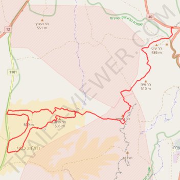
- Distance: 32.4 Km
- Elevation gain: 723 m
- Maximum elevation: 551 m
- Elevation loss: 723 m
- Minimum elevation: 414 m
- Moving time: 8 h 55 m
- Moving speed: 3.6 Km/h
- Maximum speed: 4.0 Km/h
- Total time: 8 h 55 m
- Global speed: 3.6 Km/h
Interactive trail map
Trail profile
- Distance: 32.4 Km
- Elevation gain: 723 m
- Maximum elevation: 551 m
- Elevation loss: 723 m
- Minimum elevation: 414 m
- Moving time: 8 h 55 m
- Moving speed: 3.6 Km/h
- Maximum speed: 4.0 Km/h
- Total time: 8 h 55 m
- Global speed: 3.6 Km/h
About this trail
Name: Har Ayt and Kasui Dunes trail, distance, elevation, map, profile, GPS track
Start: 40, Hevel Eilot Regional Council, Beersheba Subdistrict, South District, Israel (30.02095 35.05856)
End: 40, Hevel Eilot Regional Council, Beersheba Subdistrict, South District, Israel (30.02095 35.05856)
Coordinates: 29.96722 34.97593 30.02107 35.05856