Victoria Park
- Distance: 1.6 Km
- Elevation gain: 7 m
- Maximum elevation: 332 m
- Elevation loss: 7 m
- Minimum elevation: 325 m
- Moving time: 15 m 34 s
- Moving speed: 6.1 Km/h
- Maximum speed: 8.4 Km/h
- Total time: 15 m 34 s
- Global speed: 6.1 Km/h
Interactive trail map
Trail profile
- Distance: 1.6 Km
- Elevation gain: 7 m
- Maximum elevation: 332 m
- Elevation loss: 7 m
- Minimum elevation: 325 m
- Moving time: 15 m 34 s
- Moving speed: 6.1 Km/h
- Maximum speed: 8.4 Km/h
- Total time: 15 m 34 s
- Global speed: 6.1 Km/h
About this trail
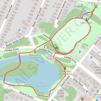
Name: Victoria Park trail, distance, elevation, map, profile, GPS track
Coordinates: 43.44575 -80.49795 43.44905 -80.49333