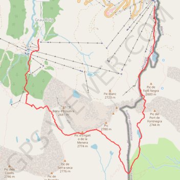
Tracks_Track2015/09/04_08:16
This is track no: 1
- Distance: 10.6 Km
- Elevation gain: 820 m
- Maximum elevation: 2,745 m
- Elevation loss: 830 m
- Minimum elevation: 2,115 m
- Moving time: 3 h 25 m
- Moving speed: 3.1 Km/h
- Maximum speed: 13.6 Km/h
- Total time: 3 h 27 m
- Global speed: 3.0 Km/h
Interactive trail map
Trail profile
- Distance: 10.6 Km
- Elevation gain: 820 m
- Maximum elevation: 2,745 m
- Elevation loss: 830 m
- Minimum elevation: 2,115 m
- Moving time: 3 h 25 m
- Moving speed: 3.1 Km/h
- Maximum speed: 13.6 Km/h
- Total time: 3 h 27 m
- Global speed: 3.0 Km/h
About this trail
Name: Tracks_Track2015/09/04_08:16 trail, distance, elevation, map, profile, GPS track
End: CS-280, Grau Roig, Encamp, AD200, Andorra (42.53277 1.70047)
Coordinates: 42.50465 1.69631 42.53955 1.73361
Other hiking, mountain biking, running and outdoor activity trails
Click on a trail to view its statistics, map and profile.
GR 10 - Traversée des Pyrénées
France > Occitania > Pyrénées-Orientales > Banyuls-sur-Mer
Distance: 874.8 Km • Elevation gain: 57,000 m • Maximum elevation: 2,599 m
1 LUCENA - MONTPELLIER
Distance: 2,964.4 Km • Elevation gain: 29,500 m • Maximum elevation: 1,048 m
Southern section — European Divide Trail
France > Auvergne-Rhône-Alpes > Drôme > Valence
Distance: 2,423.8 Km • Elevation gain: 42,375 m • Maximum elevation: 2,005 m
Tracks_Track2015/09/05_08:19
This is track no: 1
Distance: 11.8 Km • Elevation gain: 749 m • Maximum elevation: 2,814 m