Mount Hayes
Hike from Androscoggin River to Mount Hayes via Centennial Trail and Mahoosuc Trail in the White Mountain National Forest. #Hiking #Mountain #Forest #Nature #River
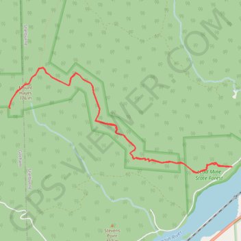
- Distance: 10.8 Km
- Elevation gain: 623 m
- Maximum elevation: 781 m
- Elevation loss: 624 m
- Minimum elevation: 237 m
- Moving time: 3 h 10 m
- Moving speed: 3.4 Km/h
- Maximum speed: 5.1 Km/h
- Total time: 3 h 50 m
- Global speed: 2.8 Km/h
Interactive trail map
Trail profile
- Distance: 10.8 Km
- Elevation gain: 623 m
- Maximum elevation: 781 m
- Elevation loss: 624 m
- Minimum elevation: 237 m
- Moving time: 3 h 10 m
- Moving speed: 3.4 Km/h
- Maximum speed: 5.1 Km/h
- Total time: 3 h 50 m
- Global speed: 2.8 Km/h
About this trail
Name: Mount Hayes trail, distance, elevation, map, profile, GPS track
Start: Hogan Road, Shelburne, Coös County, New Hampshire, United States (44.40406 -71.12007)
End: Hogan Road, Shelburne, Coös County, New Hampshire, 03581, United States (44.40403 -71.12013)
Coordinates: 44.40315 -71.16341 44.41777 -71.12007