New path at top of Berryfields
- Distance: 7.8 Km
- Elevation gain: 38 m
- Maximum elevation: 84 m
- Elevation loss: 38 m
- Minimum elevation: 70 m
Interactive trail map
Trail profile
- Distance: 7.8 Km
- Elevation gain: 38 m
- Maximum elevation: 84 m
- Elevation loss: 38 m
- Minimum elevation: 70 m
About this trail
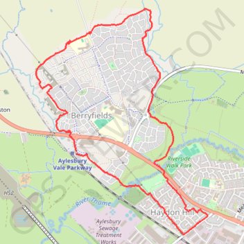
Name: New path at top of Berryfields trail, distance, elevation, map, profile, GPS track
Coordinates: 51.82376 -0.86523 51.84446 -0.83974
Other hiking, mountain biking, running and outdoor activity trails
Click on a trail to view its statistics, map and profile.
The Jo Cox Way 2022 Day 4 - Milton Keynes to Uxbridge
United Kingdom > England > City of Milton Keynes > Milton Keynes > Monkston
Distance: 104.4 Km • Elevation gain: 1,038 m • Maximum elevation: 251 m