Walk to the Doneens & top of Glencarr Waterfall
Glencarr Wood Walk
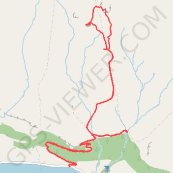
- Distance: 8.8 Km
- Elevation gain: 407 m
- Maximum elevation: 424 m
- Elevation loss: 408 m
- Minimum elevation: 39 m
- Moving time: 2 h 4 m
- Moving speed: 4.2 Km/h
- Maximum speed: 9.3 Km/h
- Total time: 2 h 29 m
- Global speed: 3.5 Km/h
Interactive trail map
Trail profile
- Distance: 8.8 Km
- Elevation gain: 407 m
- Maximum elevation: 424 m
- Elevation loss: 408 m
- Minimum elevation: 39 m
- Moving time: 2 h 4 m
- Moving speed: 4.2 Km/h
- Maximum speed: 9.3 Km/h
- Total time: 2 h 29 m
- Global speed: 3.5 Km/h
About this trail
Name: Walk to the Doneens & top of Glencarr Waterfall trail, distance, elevation, map, profile, GPS track
Start: Glencar ED, Manorhamilton Municipal District, County Leitrim, Connacht, Ireland (54.34084 -8.37501)
Coordinates: 54.34073 -8.37938 54.35856 -8.36382
Other hiking, mountain biking, running and outdoor activity trails
Click on a trail to view its statistics, map and profile.
CTS-N.Irelandv1.1-Belfast-Titanic>Enniscrone-via antrim coast-209miles
United Kingdom > Northern Ireland > County Down > Belfast
Distance: 335.8 Km • Elevation gain: 3,985 m • Maximum elevation: 271 m