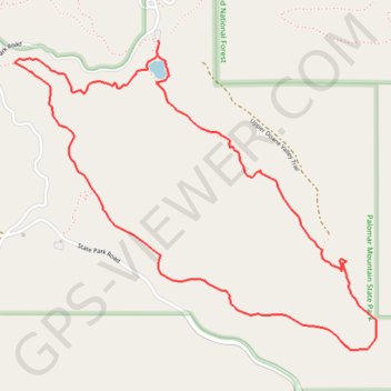
Doane Pond Loop
Loop hike from Doane Pond by Thunder Spring Trail, Chimney Flats Trail, Scott's Cabin Trail and Cedar Trail in the Palomar Mountains State Park. #Hiking #Loop #Lake #Forest #Mountain #Nature #Park
- Distance: 6.3 Km
- Elevation gain: 280 m
- Maximum elevation: 1,638 m
- Elevation loss: 280 m
- Minimum elevation: 1,421 m
Interactive trail map
Trail profile
- Distance: 6.3 Km
- Elevation gain: 280 m
- Maximum elevation: 1,638 m
- Elevation loss: 280 m
- Minimum elevation: 1,421 m
About this trail
Name: Doane Pond Loop trail, distance, elevation, map, profile, GPS track
Start: Doane Valley Nature Trail, San Diego County, California, United States (33.34147 -116.90131)
End: Doane Valley Nature Trail, San Diego County, California, United States (33.34138 -116.90126)
Coordinates: 33.32706 -116.90933 33.34147 -116.88917
Other hiking, mountain biking, running and outdoor activity trails
Click on a trail to view its statistics, map and profile.
Doane Valley Loop
United States > California > San Diego County
Loop hike through Doane Valley Natural Preserve via Weir Trail, Weir Historic Site, French Valley Trail, Rest spot between two waterfalls and Doane Valley Nature Trail in Palomar Mountain State Park. #Hiking #Loop #Mountain #Valley #Nature #Forest #Park #River
Distance: 6.4 Km • Elevation gain: 156 m • Maximum elevation: 1,432 m