Ham woods
- Distance: 5.7 Km
- Elevation gain: 118 m
- Maximum elevation: 75 m
- Elevation loss: 90 m
- Minimum elevation: 18 m
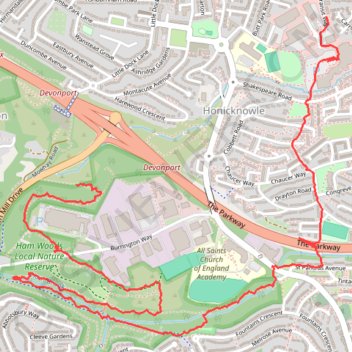
Interactive trail map
Trail profile
- Distance: 5.7 Km
- Elevation gain: 118 m
- Maximum elevation: 75 m
- Elevation loss: 90 m
- Minimum elevation: 18 m
About this trail
Name: Ham woods trail, distance, elevation, map, profile, GPS track
Start: Weston Mill Lane, Kings Tamerton, Plymouth, England, PL5 3LZ, United Kingdom (50.40514 -4.16531)
End: Transit Way, Manadon, Crownhill, Plymouth, England, PL5 3TW, United Kingdom (50.41141 -4.15072)
Coordinates: 50.39952 -4.16902 50.41141 -4.14995