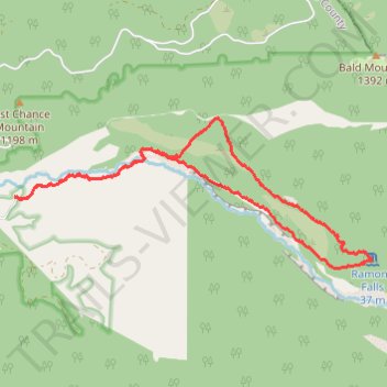
Ramona Falls Loop via Sandy River Trail, Pacific Crest Trail and Ramona Falls Trail
The Ramona Falls Loop in Oregon's Mount Hood Wilderness offers hikers a journey through lush forests, a crossing over the Sandy River, and the serene beauty of Ramona Falls cascading over basalt columns. Along the trail, one can enjoy views of Mount Hood and vibrant rhododendron blooms in season. The path is well-maintained and suitable for most hikers, though the unbridged river crossing can present a challenge. #Hiking #Mountain #Forest #Nature #Loop #Waterfall #River
- Distance: 12.1 Km
- Elevation gain: 399 m
- Maximum elevation: 1,097 m
- Elevation loss: 399 m
- Minimum elevation: 751 m
- Moving time: 2 h 45 m
- Moving speed: 4.4 Km/h
- Maximum speed: 12.6 Km/h
- Total time: 3 h 43 m
- Global speed: 3.2 Km/h
Interactive trail map
Trail profile
- Distance: 12.1 Km
- Elevation gain: 399 m
- Maximum elevation: 1,097 m
- Elevation loss: 399 m
- Minimum elevation: 751 m
- Moving time: 2 h 45 m
- Moving speed: 4.4 Km/h
- Maximum speed: 12.6 Km/h
- Total time: 3 h 43 m
- Global speed: 3.2 Km/h
About this trail
Name: Ramona Falls Loop via Sandy River Trail, Pacific Crest Trail and Ramona Falls Trail trail, distance, elevation, map, profile, GPS track
Coordinates: 45.37892 -121.83242 45.39554 -121.77620
Other hiking, mountain biking, running and outdoor activity trails
Click on a trail to view its statistics, map and profile.
Northern part of the Pacific Crest Trail (PCT)
United States > Oregon > Klamath County
Hike on the Pacific Crest National Scenic Trail from Crater Lake to Canada Border through Oregon and Washington along the Sierra Nevada and Cascade mountain ranges. #Hiking #Mountain #SierraNevada #Cascade #Nature #Forest #Park #PCT
Distance: 1,198.3 Km • Elevation gain: 44,308 m • Maximum elevation: 2,307 m