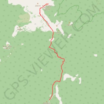
Trail - Three Brothers Mountain
Canada, BC, EC Manning Provincial Park
- Distance: 21.3 Km
- Elevation gain: 842 m
- Maximum elevation: 2,251 m
- Elevation loss: 842 m
- Minimum elevation: 1,788 m
- Moving time: 5 h 12 m
- Moving speed: 4.1 Km/h
- Maximum speed: 10.4 Km/h
- Total time: 7 h 9 m
- Global speed: 3.0 Km/h
Interactive trail map
Trail profile
- Distance: 21.3 Km
- Elevation gain: 842 m
- Maximum elevation: 2,251 m
- Elevation loss: 842 m
- Minimum elevation: 1,788 m
- Moving time: 5 h 12 m
- Moving speed: 4.1 Km/h
- Maximum speed: 10.4 Km/h
- Total time: 7 h 9 m
- Global speed: 3.0 Km/h
About this trail
Name: Trail - Three Brothers Mountain trail, distance, elevation, map, profile, GPS track
Coordinates: 49.09881 -120.77578 49.16615 -120.74899
Other hiking, mountain biking, running and outdoor activity trails
Click on a trail to view its statistics, map and profile.