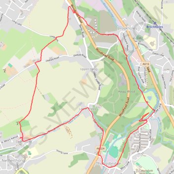
Netherthong, River Holme Riverside Loop Walk
- Distance: 6.2 Km
- Elevation gain: 124 m
- Maximum elevation: 215 m
- Elevation loss: 124 m
- Minimum elevation: 119 m
- Moving time: 1 h 51 m
- Moving speed: 3.3 Km/h
- Maximum speed: 33.6 Km/h
- Total time: 3 h 10 m
- Global speed: 1.9 Km/h
Interactive trail map
Trail profile
- Distance: 6.2 Km
- Elevation gain: 124 m
- Maximum elevation: 215 m
- Elevation loss: 124 m
- Minimum elevation: 119 m
- Moving time: 1 h 51 m
- Moving speed: 3.3 Km/h
- Maximum speed: 33.6 Km/h
- Total time: 3 h 10 m
- Global speed: 1.9 Km/h
About this trail
Name: Netherthong, River Holme Riverside Loop Walk trail, distance, elevation, map, profile, GPS track
Coordinates: 53.58349 -1.79122 53.59856 -1.76974
Other hiking, mountain biking, running and outdoor activity trails
Click on a trail to view its statistics, map and profile.
Netherthong, River Holme and Hagg Wood loop
United Kingdom > England > Kirklees > Netherthong > Deanhouse
Distance: 5.2 Km • Elevation gain: 104 m • Maximum elevation: 204 m