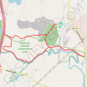
Morning round trip around Nashua River from Lancaster
Lancaster Trails, Cook Conservation Area, Nashua River, Chapman-Goodale Conservation Land, Lancaster State Forest
- Distance: 9.2 Km
- Elevation gain: 91 m
- Maximum elevation: 115 m
- Elevation loss: 91 m
- Minimum elevation: 76 m
- Moving time: 1 h 53 m
- Moving speed: 4.8 Km/h
- Maximum speed: 14.2 Km/h
- Total time: 1 h 59 m
- Global speed: 4.6 Km/h
Interactive trail map
Trail profile
- Distance: 9.2 Km
- Elevation gain: 91 m
- Maximum elevation: 115 m
- Elevation loss: 91 m
- Minimum elevation: 76 m
- Moving time: 1 h 53 m
- Moving speed: 4.8 Km/h
- Maximum speed: 14.2 Km/h
- Total time: 1 h 59 m
- Global speed: 4.6 Km/h
About this trail
Name: Morning round trip around Nashua River from Lancaster trail, distance, elevation, map, profile, GPS track
Coordinates: 42.49192 -71.72107 42.50429 -71.68652
Other hiking, mountain biking, running and outdoor activity trails
Click on a trail to view its statistics, map and profile.
Loop in Eastern Mass involving various rail trails
United States > Massachusetts > Middlesex County > Newton
Distance: 203.8 Km • Elevation gain: 1,940 m • Maximum elevation: 194 m