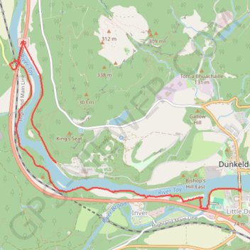
Walk over A9 bridge over River Braan by pedestrian pavement (sidewalk) and small diversion for SGN gas pipeline route then Fiddlers path
- Distance: 6.0 Km
- Elevation gain: 79 m
- Maximum elevation: 76 m
- Elevation loss: 64 m
- Minimum elevation: 48 m
- Moving time: 1 h 14 m
- Moving speed: 4.8 Km/h
- Maximum speed: 14.0 Km/h
- Total time: 1 h 16 m
- Global speed: 4.7 Km/h
Interactive trail map
Trail profile
- Distance: 6.0 Km
- Elevation gain: 79 m
- Maximum elevation: 76 m
- Elevation loss: 64 m
- Minimum elevation: 48 m
- Moving time: 1 h 14 m
- Moving speed: 4.8 Km/h
- Maximum speed: 14.0 Km/h
- Total time: 1 h 16 m
- Global speed: 4.7 Km/h
About this trail
Name: Walk over A9 bridge over River Braan by pedestrian pavement (sidewalk) and small diversion for SGN gas pipeline route then Fiddlers path trail, distance, elevation, map, profile, GPS track
Start: Dunkeld Bridge, Dunkeld, Perth and Kinross, Scotland, PH8 0AQ, United Kingdom (56.56329 -3.58516)
End: A9, Inver, Perth and Kinross, Scotland, PH8 0JR, United Kingdom (56.56569 -3.61595)
Coordinates: 56.56141 -3.62376 56.57691 -3.58509
Other hiking, mountain biking, running and outdoor activity trails
Click on a trail to view its statistics, map and profile.
Cally Loch Mountain Bike Ride, Dunkeld
United Kingdom > Scotland > Perth and Kinross
Distance: 38.7 Km • Elevation gain: 605 m • Maximum elevation: 189 m
Falls of the Braan and River Tay loop trail
United Kingdom > Scotland > Perth and Kinross > Dunkeld > Inchmagrannachan
Distance: 10.9 Km • Elevation gain: 234 m • Maximum elevation: 186 m
Tracks, MTB and off track sections to visit the Rocking Stone and Polney Crag
United Kingdom > Scotland > Perth and Kinross > Dunkeld > Inchmagrannachan
Distance: 3.6 Km • Elevation gain: 172 m • Maximum elevation: 321 m
Craigvinean Forest Loop MTB, Dunkeld, Perthshire
United Kingdom > Scotland > Perth and Kinross > Inver
Mountain Bike Ride, UK, Perthshire, Dunkeld
Distance: 21.3 Km • Elevation gain: 562 m • Maximum elevation: 362 m
Mountain Bike Ride around Craigvinean Forest
United Kingdom > Scotland > Perth and Kinross > Inver
UK, Perthshire, Dunkeld
Distance: 7.7 Km • Elevation gain: 328 m • Maximum elevation: 334 m
EMTB Gravel: Murthly - Birnam - Loop
United Kingdom > Scotland > Perth and Kinross > Newlands
Around Dunkeld, Perthshire Scotland
Distance: 46.4 Km • Elevation gain: 869 m • Maximum elevation: 305 m
Walk around King's Seat. Tracing lines of defence and paths
United Kingdom > Scotland > Perth and Kinross > Inver
Distance: 2.2 Km • Elevation gain: 74 m • Maximum elevation: 152 m
Around Loch Ordie
United Kingdom > Scotland > Perth and Kinross
Mountain Bike Ride, UK, Perthshire, Dunkeld
Distance: 35.8 Km • Elevation gain: 579 m • Maximum elevation: 300 m
Inver Wood Roads
United Kingdom > Scotland > Perth and Kinross > Inver
Finding the route of the old roads
Distance: 1.6 Km • Elevation gain: 34 m • Maximum elevation: 83 m
Track of the split tracks 😅
United Kingdom > Scotland > Perth and Kinross > Inver
Distance: 1.1 Km • Elevation gain: 17 m • Maximum elevation: 68 m