Thank you for supporting this site ❤️
Make a donation
Make a donation
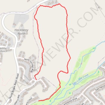
In the hills north of Boise
- Distance: 3.2 Km
- Elevation gain: 83 m
- Maximum elevation: 1,030 m
- Elevation loss: 136 m
- Minimum elevation: 907 m
- Moving time: 57 m 2 s
- Moving speed: 3.3 Km/h
- Maximum speed: 6.8 Km/h
- Total time: 57 m 2 s
- Global speed: 3.3 Km/h
Interactive trail map
Thank you for supporting this site ❤️
Make a donation
Make a donation
Trail profile
- Distance: 3.2 Km
- Elevation gain: 83 m
- Maximum elevation: 1,030 m
- Elevation loss: 136 m
- Minimum elevation: 907 m
- Moving time: 57 m 2 s
- Moving speed: 3.3 Km/h
- Maximum speed: 6.8 Km/h
- Total time: 57 m 2 s
- Global speed: 3.3 Km/h
Thank you for supporting this site ❤️
Make a donation
Make a donation
About this trail
Name: In the hills north of Boise trail, distance, elevation, map, profile, GPS track
Start: North Torridon Way, Highlands, Boise, Ada County, Idaho, 83702, United States (43.65640 -116.18643)
Coordinates: 43.65384 -116.18671 43.66567 -116.18068
Thank you for supporting this site ❤️
Make a donation
Make a donation