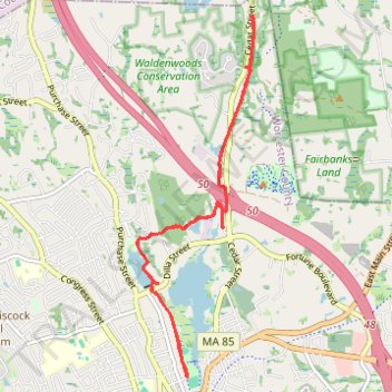
Upper Charles River rail trail from Luisa Lake parking
- Distance: 13.3 Km
- Elevation gain: 81 m
- Maximum elevation: 105 m
- Elevation loss: 81 m
- Minimum elevation: 83 m
- Moving time: 1 h 18 m
- Moving speed: 10.2 Km/h
- Maximum speed: 26.4 Km/h
- Total time: 1 h 27 m
- Global speed: 9.1 Km/h
Interactive trail map
Trail profile
- Distance: 13.3 Km
- Elevation gain: 81 m
- Maximum elevation: 105 m
- Elevation loss: 81 m
- Minimum elevation: 83 m
- Moving time: 1 h 18 m
- Moving speed: 10.2 Km/h
- Maximum speed: 26.4 Km/h
- Total time: 1 h 27 m
- Global speed: 9.1 Km/h
About this trail
Name: Upper Charles River rail trail from Luisa Lake parking trail, distance, elevation, map, profile, GPS track
Coordinates: 42.14562 -71.52286 42.18785 -71.50451
Other hiking, mountain biking, running and outdoor activity trails
Click on a trail to view its statistics, map and profile.
Loop in Eastern Mass involving various rail trails
United States > Massachusetts > Middlesex County > Newton
Distance: 203.8 Km • Elevation gain: 1,940 m • Maximum elevation: 194 m
Cambridge - Providence Express
United States > Massachusetts > Middlesex County > Cambridge
Alewife -> Providence
Distance: 101.8 Km • Elevation gain: 961 m • Maximum elevation: 107 m
Dedham-Providence-Dedham
United States > Massachusetts > Norfolk County > Dedham
Distance: 202.8 Km • Elevation gain: 1,811 m • Maximum elevation: 167 m