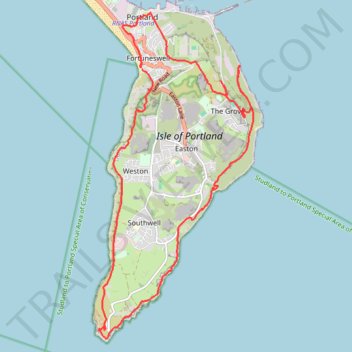
Isle of Portland Loop
- Distance: 20.7 Km
- Elevation gain: 585 m
- Maximum elevation: 133 m
- Elevation loss: 593 m
- Minimum elevation: 0 m
- Moving time: 5 h 15 m
- Moving speed: 3.9 Km/h
- Maximum speed: 7.2 Km/h
- Total time: 6 h 43 s
- Global speed: 3.4 Km/h
Interactive trail map
Trail profile
- Distance: 20.7 Km
- Elevation gain: 585 m
- Maximum elevation: 133 m
- Elevation loss: 593 m
- Minimum elevation: 0 m
- Moving time: 5 h 15 m
- Moving speed: 3.9 Km/h
- Maximum speed: 7.2 Km/h
- Total time: 6 h 43 s
- Global speed: 3.4 Km/h
About this trail
Name: Isle of Portland Loop trail, distance, elevation, map, profile, GPS track
Start: Cove Cottages, Portland, Fortuneswell, Dorset, England, DT5 1JJ, United Kingdom (50.55840 -2.44736)
End: Brandy Row, Portland, Fortuneswell, Dorset, England, DT5 1AP, United Kingdom (50.55929 -2.44765)
Coordinates: 50.51341 -2.45878 50.56779 -2.41804